
Hello Fitfam,
Welcome to the San Francisco Series!
In this series, I cover ‘Things To See and Do’ in San Francisco for the healthy, active tourist.
There are so many iconic places to visit while you’re in San Francisco but my blog aims to give you some extra ideas for those of us that love being outdoors, living an active lifestyle, staying fit or just have a love of all things healthy.
‘Frisco’, ‘The Bay’, ‘San Fran’ or ‘SF’, are just a few names you may hear this beautiful, eclectic, hilly and unique city in Northern California being called. With so much to do here, you can be excused for visiting time and time again!
In this post I cover one of my favourite things to do in San Francisco….
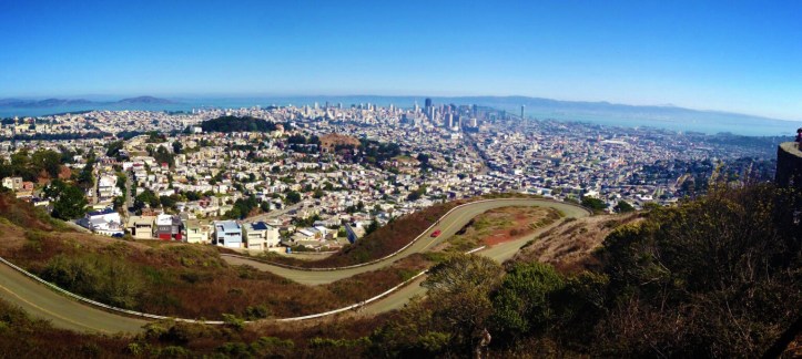
Hike to the top of Twin Peaks
The 360 degree panoramic views you will experience at the top of Twin Peaks – two hills standing over 920 feet tall in the geographical centre of San Francisco, is something I will never get bored of visiting. Now, you can drive to the top or visit the peaks on a tour bus but I can assure you there is no better way to truly experience the breath taking views of the city, the bay, the ocean and California beyond, than to hike to the top. Be sure to make your first visit on a ‘good weather’ day, as the last thing you will want to find is the city below covered in cloud. Although I say ‘first visit’, as I think the famous ‘fog’ encroaching the city from the west on a cold day, can make fantastic viewing for someone that has been before. Twin Peaks is a popular place for tourists AND locals. On the way up you will most likely pass runners, cyclists and if your lucky, a few dog walkers and their furry companions! Although, the cute dogs might not be the only wildlife you encounter on the hike, racoons and skunks are also known to hang out nearby. While i was there, I got to see a couple of Red Tail Hawk’s gliding in the air (not that high) above me! When you get to the top there are two hills to trek, to help you observe the whole city. You’ll find strong winds and fog coming from the west, while sun and warmth immerse the east of the city. In-between the crest of the two hills you will find a helpful map of the bay area that can come in useful when your trying to remember what a certain park or road, you are looking at, is called. The convenient map is right next to some even more convenient bathrooms!
How to get there…
The simplest route to take, starting on Market Street, head through SoMa and Castro until you reach Portola. From Portola take a right onto Twin Peaks Boulevard and follow the road all the up to the top! Simple. If you want to add some more interesting sights and a level of difficulty, when you get to Castro or the end of Market Street use the alleyways of steep steps to take you to the top. A map app on my phone helped guide me up, the often hidden, staircases but if you don’t have access to a map then I suggest you staying with the simpler route above. From SoMa, it took roughly 90 minutes to get to the top, where I stayed for the best part of an hour, just gazing at the city I have come to know so well, before heading back down. 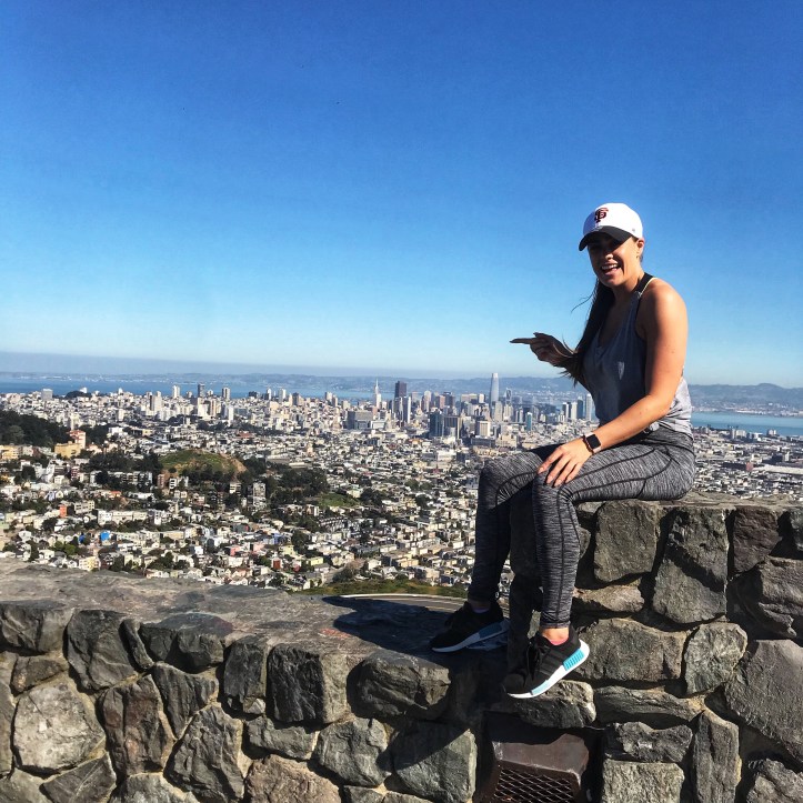
I hope you enjoy the series and I’d love to hear from you with any feedback or questions, and if theres anything you’d like to see in future blogs, the San Francisco Series or others, just get in touch through my socials (links below).
Lilfitmiss 💋💋
Other posts in this series

[…] Twin Peaks – San Francisco Series […]
[…] Hike Twin Peaks […]